*DENSE FOG ADVISORY for Land areas until 10 AM*
*MARINE DENSE FOG ADVISORY for Lakes & Gulf until 11 AM*
*MARINE DENSE FOG ADVISORY for Lakes & Gulf until 11 AM*
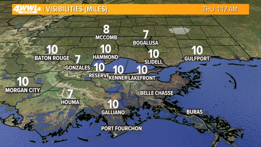 More dense fog is expected throughout the morning and across the entire area. Visibility will be less than 1/4 mile in many places. Fog restrictions are in place on the Causeway. Drive safely and take your time!
  After a foggy start to this Wednesday, we will be mostly cloudy and still very mild this afternoon with spotty showers. Expect some near record highs in the upper 70s again. The record is 79° set back in 1974.
The weather will start to change and go downhill tonight ahead of a cold front. We will be mostly cloudy with some fog, but scattered showers and thunderstorms will move into the region toward daybreak. Some heavy rain will be possible. Lows will be in the mid 60s.
 The strong cold front will move through on Thursday. It will be very mild and humid ahead of it, so the atmosphere will be unstable. This will allow for the thunderstorms to become strong to possibly severe at times. The main threat would be damaging winds and hail, but a few tornadoes are possible. Heavy rain is also likely, and we could pick up 1 to 2 inches of rain. However, I'm not expecting any flooding issues since it has been dry lately. Just watch out for street flooding. Highs will be in the mid 70s. The rain will gradually come to an end on Thursday Night as the cold front moves through. We will not cool down with lows in the 60s and some patchy fog will be possible.
Friday will be a dry day as we wait for our next cold front that arrives on Saturday. Expect partly cloudy skies and mild highs in the mid 70s. Rain and storms return Friday Night with lows in the 60s.

The cold front that is headed our way on Saturday could bring us some severe storms. We will be very mild and humid with highs in the mid 70s ahead of the front, and that will make it unstable again. These storms could bring us damaging winds, hail and a few tornadoes. It looks like the severe weather threat will be greater on Saturday vs. Thursday. We will have to keep a close eye on the storms. Heavy rain is also likely and we could pick up 1-2 inches. However, I'm not expecting any flooding issues.
 The storms will continue on Saturday Night into Sunday. Again, they could be strong to severe. Lows will be in the 60s. The storms will come to an end during the day on Sunday as the cold front moves through. Highs will be around 70.
Much cooler air arrives on Monday with highs in the 60s under sunny skies.
Comments