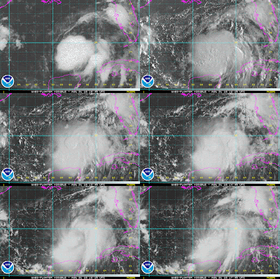
Tropical Depression 9 has strengthened into Tropical Storm Hermine with 40 mph winds. It is producing more convection today and is a little better organized. This is due to less wind shear moving over the system. You can see outflow on the satellite images, and this is a sign that the storm is getting better organized. Hermine will continue to slowly get stronger today as it moves over very warm water temps. in the upper 80s. with only moderate wind shear over the system. It is currently stationary, and that is ok. This just lets the trough of low pressure dig deeper across the Eastern U.S., and it will be pulling Hermine to the NNE later this evening.
The trough of low pressure over the Eastern U.S. and will continue to pull Hermine to the
north and NE through Thursday. At the same time, a cold front will also be moving south with the trough to help send Hermine away from Louisiana and into the Florida Panhandle. While this is happening, Hermine will go through some moderate wind shear and the upper 80° water temperatures. This will cause it to get stronger with winds likely around 65 mph as it moves NE toward the Florida Panhandle. Once it gets closer to shore, it will encounter some strong wind shear from the trough and cold front. This will prevent it from getting too strong as it makes landfall.
Tropical Storm Warnings have been issued for parts of the Florida Panhandle and Big Bend
area stretching from Panama City east to just north of Tampa. This is the area that will see tropical storm force winds and a storm surge around 3 to 5 feet.
Then this system will quickly move over FL and GA and emerge in the Atlantic Ocean near Charleston, SC on Friday.
Labor Day Weekend: If you are traveling to Destin or
Panama City for the long holiday weekend, the weather will be pretty good. I would delay your trip until Friday vs going on Thursday. Friday through Monday will be partly to mostly cloudy and hot with a 30-40% chance for storms each day as the cold front stalls over the I-10 corridor and dissipates. Overall, it will be some decent weather at the beaches.
Be sure to check back with my blog updates and my posts on Facebook, Twitter and on WWL-TV over the next few days. Stay weather aware! -Dave


Comments