Each year in April, a group of forecasters from Colorado State University lead by Dr. Philip Klotzbach and Dr. William Gray. They have been doing this for decades and this gives us an idea of how the hurricane season could play out. Yes, we take this as a grain of salt because it could easily change. However, it still helps to have a guide.
They look at a number of things from global atmospheric conditions, oceanic conditions, climate history and weather patterns to put together a forecast. After all of their analysis, they have concluded that we will have a below average 2015 Hurricane Season.
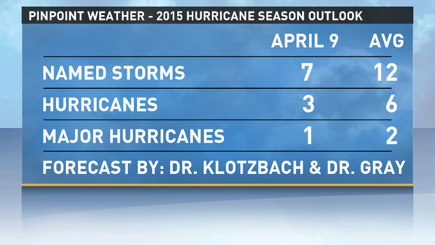
The main factors for fewer storms this season is the likelihood for a moderate El Nino to form and cool Atlantic Ocean water temperatures. When you have an El Nino you typically have more wind shear across the Globe and that makes it hard for storms to develop and persist. Yes, it is still possible for some to form and become hurricanes, but you would not have as many if an El Nino didn't exist. The cool water temperatures are also a problem when a storm tries to form. You need minimum water temperatures to be around 80° to maintain a storm. Anything less than that makes it hard for the storm to thrive.

Again, take this as a grain of salt,but it would be nice not to have many storms. Remember, it only takes one to make an active season. 1992 was not an active season, but we had Hurricane Andrew. 1957 was not an active season, but we had Hurricane Audrey - the earliest major hurricane ever to make landfall in the U.S.
We are still less than 2 months away from the start of hurricane season (June 1st). Now is the time to get prepared. Check your hurricane kits and refresh them with batteries, water, supplies, etc. now before you need the supplies and it is too late!
Make sure you keep it tuned to WWL-TV this hurricane season for daily updates and more!
They look at a number of things from global atmospheric conditions, oceanic conditions, climate history and weather patterns to put together a forecast. After all of their analysis, they have concluded that we will have a below average 2015 Hurricane Season.
The main factors for fewer storms this season is the likelihood for a moderate El Nino to form and cool Atlantic Ocean water temperatures. When you have an El Nino you typically have more wind shear across the Globe and that makes it hard for storms to develop and persist. Yes, it is still possible for some to form and become hurricanes, but you would not have as many if an El Nino didn't exist. The cool water temperatures are also a problem when a storm tries to form. You need minimum water temperatures to be around 80° to maintain a storm. Anything less than that makes it hard for the storm to thrive.
Again, take this as a grain of salt,but it would be nice not to have many storms. Remember, it only takes one to make an active season. 1992 was not an active season, but we had Hurricane Andrew. 1957 was not an active season, but we had Hurricane Audrey - the earliest major hurricane ever to make landfall in the U.S.
We are still less than 2 months away from the start of hurricane season (June 1st). Now is the time to get prepared. Check your hurricane kits and refresh them with batteries, water, supplies, etc. now before you need the supplies and it is too late!
Make sure you keep it tuned to WWL-TV this hurricane season for daily updates and more!
Comments