...Hard Freeze Warning from 7 PM Tonight Until 9 AM Thursday...
Short Term Forecast: The rain has finally ended across the Baton Rouge area and the skies are now clear. It is chilly and brisk with temperatures in the 30s. Bundle up as you head out the door!!
.
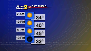
We will finally see the sun this afternoon! Both areas of low pressure have moved northeast of Louisiana. Now an area of high pressure will build in from the northwest over us. This will make it clear, but it will also draw down some very cold temperatures. I am expecting some breezy conditions today, so plan on it being brisk all day. High temperatures will only be in the mid 40s this afternoon. Brrr!
Bitter cold temperatures are expected tonight across Southeast Louisiana. We will be clear and the winds will be very light. Lows will drop into the mid 20s. The NWS has issued a Hard Freeze Warning for most of the viewing area along and north of I-10/12. The freeze is expected to last 3 to 7 hours. This will be cold enough to kill any vegetation. Bring in any plants you want to keep. Also have a warm place for your pets, wrap any exposed pipes and check on those that may not have heat. Stay warm!!

Thanksgiving Day: It will be a bitter cold start to the day for you early risers! We will have a gorgeous day with plenty of sunshine and it will be a tad warmer with highs in the lower 50s. Thursday Night will be clear and very cold again with lows in the upper 20s.
Black Friday: Those of you that plan on getting up early to go shopping better have a very warm coat on while you wait in line! We will start the day with clear skies and very cold temperatures in the upper 20s. It will become much warmer by the afternoon with sunny skies and high temperatures around 60. Friday Night will be clear and not as cold. However, it will still be chilly with lows in the lower 30s.
LSU Game: If you are headed to the Arkansas vs LSU game then plan for some cool and sunny weather. Tailgating temperatures around 10 AM will be chilly as they sit around 40. Kickoff temperatures at 1:30 PM will be around 60 and when the game is over it will be clear with temperatures around 50.
Bayou Classic: The weather will be very nice for the Southern Game on Saturday at 1:30 PM. Of course the game is inside the Mercedes-Benz Superdome, but the weather outside will be sunny with kickoff temperatures in the 60s.
Weekend Forecast: The area of high pressure will remain over us on Saturday and it will be another beautiful day with sunny skies. It will be warmer with highs in the mid 60s and lows will not be as cold, but still chilly with lows in the lower 40s.

The high pressure will move east of Louisiana on Sunday and that will bring back southerly winds. This will make it even warmer with highs in the upper 60s under partly cloudy skies. Lows will not be as chilly as they fall to the lower 50s under partly cloudy skies.
Tropical Outlook: All areas of the Tropical Atlantic Basin are quiet, and they will stay quiet through Thursday.
Bundle up, enjoy the sunshine and have a great day! -Dave
Short Term Forecast: The rain has finally ended across the Baton Rouge area and the skies are now clear. It is chilly and brisk with temperatures in the 30s. Bundle up as you head out the door!!
.

We will finally see the sun this afternoon! Both areas of low pressure have moved northeast of Louisiana. Now an area of high pressure will build in from the northwest over us. This will make it clear, but it will also draw down some very cold temperatures. I am expecting some breezy conditions today, so plan on it being brisk all day. High temperatures will only be in the mid 40s this afternoon. Brrr!
Bitter cold temperatures are expected tonight across Southeast Louisiana. We will be clear and the winds will be very light. Lows will drop into the mid 20s. The NWS has issued a Hard Freeze Warning for most of the viewing area along and north of I-10/12. The freeze is expected to last 3 to 7 hours. This will be cold enough to kill any vegetation. Bring in any plants you want to keep. Also have a warm place for your pets, wrap any exposed pipes and check on those that may not have heat. Stay warm!!

Thanksgiving Day: It will be a bitter cold start to the day for you early risers! We will have a gorgeous day with plenty of sunshine and it will be a tad warmer with highs in the lower 50s. Thursday Night will be clear and very cold again with lows in the upper 20s.
Black Friday: Those of you that plan on getting up early to go shopping better have a very warm coat on while you wait in line! We will start the day with clear skies and very cold temperatures in the upper 20s. It will become much warmer by the afternoon with sunny skies and high temperatures around 60. Friday Night will be clear and not as cold. However, it will still be chilly with lows in the lower 30s.
LSU Game: If you are headed to the Arkansas vs LSU game then plan for some cool and sunny weather. Tailgating temperatures around 10 AM will be chilly as they sit around 40. Kickoff temperatures at 1:30 PM will be around 60 and when the game is over it will be clear with temperatures around 50.
Bayou Classic: The weather will be very nice for the Southern Game on Saturday at 1:30 PM. Of course the game is inside the Mercedes-Benz Superdome, but the weather outside will be sunny with kickoff temperatures in the 60s.
Weekend Forecast: The area of high pressure will remain over us on Saturday and it will be another beautiful day with sunny skies. It will be warmer with highs in the mid 60s and lows will not be as cold, but still chilly with lows in the lower 40s.
The high pressure will move east of Louisiana on Sunday and that will bring back southerly winds. This will make it even warmer with highs in the upper 60s under partly cloudy skies. Lows will not be as chilly as they fall to the lower 50s under partly cloudy skies.
Tropical Outlook: All areas of the Tropical Atlantic Basin are quiet, and they will stay quiet through Thursday.
Bundle up, enjoy the sunshine and have a great day! -Dave
Comments