Short Term Forecast: We have a much cooler start to the day across Southeast Louisiana. It is partly to mostly cloudy with temperatures in the 50s. You may want that light jacket or sweater this morning!
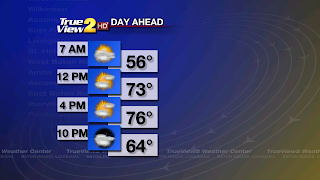
We will have a pretty nice afternoon as a cold front is stalled along the Louisiana Coast. You can expect to see a mix of sun and clouds with a few showers possible late in the day. High temperatures will be in the mid to upper 70s.
The weather will go downhill tonight. A disturbance/wave, or area of low pressure aloft, will form over Texas and move along the stalled cold front. This will help to set off scattered showers and some thunderstorms overnight into Saturday Morning. Some heavy rain will be possible, but mainly along the Coastal Parishes. A few inches of rain is possible there. Here in Baton Rouge we will just have scattered showers with some heavy downpours. Low temperatures will be in the upper 50s.
Weekend Forecast: It looks like we will start the weekend with some rain, but it will end with plenty of sunshine. The rainy weather is thanks to that disturbance. It will continue to ride along the stalled cold front on Saturday Morning, and then it will move out of the area by Saturday Afternoon. At the same time, another cold front will move into Baton Rouge from the northwest and that will clear out the rain. Highs will be in the mid 70s. Saturday Night will be mostly clear to partly cloudy and it will become MUCH COOLER with lows in the lower 50s!

Sunday will turn out to be a very nice dry day. It will be partly cloudy with low humidity and high temperatures in the upper 70s. Sunday Night will be partly cloudy with lows in the upper 50s.
Next Week Outlook: The forecast models are showing another cold front and disturbance pushing across Louisiana to start the week. This means we will have more scattered showers on Monday into Tuesday. Once the front passes through Baton Rouge on Tuesday Morning we will have some drier and MUCH COOLER weather the rest of the week. Actually, we may see some of the coldest temperatures so far this Fall! Daily highs will be in the lower to mid 70s during the week. Low temperatures will be in the 60s Monday Night, but will be in the upper 40s by Wednesday Night! Brrr!!
Tropical Outlook: Everything is quiet in the tropics and it will stay that way through the next 5 days.
Grab a light jacket this morning and an umbrella on Saturday. Have a great weekend! -Dave

We will have a pretty nice afternoon as a cold front is stalled along the Louisiana Coast. You can expect to see a mix of sun and clouds with a few showers possible late in the day. High temperatures will be in the mid to upper 70s.
The weather will go downhill tonight. A disturbance/wave, or area of low pressure aloft, will form over Texas and move along the stalled cold front. This will help to set off scattered showers and some thunderstorms overnight into Saturday Morning. Some heavy rain will be possible, but mainly along the Coastal Parishes. A few inches of rain is possible there. Here in Baton Rouge we will just have scattered showers with some heavy downpours. Low temperatures will be in the upper 50s.
Weekend Forecast: It looks like we will start the weekend with some rain, but it will end with plenty of sunshine. The rainy weather is thanks to that disturbance. It will continue to ride along the stalled cold front on Saturday Morning, and then it will move out of the area by Saturday Afternoon. At the same time, another cold front will move into Baton Rouge from the northwest and that will clear out the rain. Highs will be in the mid 70s. Saturday Night will be mostly clear to partly cloudy and it will become MUCH COOLER with lows in the lower 50s!
Sunday will turn out to be a very nice dry day. It will be partly cloudy with low humidity and high temperatures in the upper 70s. Sunday Night will be partly cloudy with lows in the upper 50s.
Next Week Outlook: The forecast models are showing another cold front and disturbance pushing across Louisiana to start the week. This means we will have more scattered showers on Monday into Tuesday. Once the front passes through Baton Rouge on Tuesday Morning we will have some drier and MUCH COOLER weather the rest of the week. Actually, we may see some of the coldest temperatures so far this Fall! Daily highs will be in the lower to mid 70s during the week. Low temperatures will be in the 60s Monday Night, but will be in the upper 40s by Wednesday Night! Brrr!!
Tropical Outlook: Everything is quiet in the tropics and it will stay that way through the next 5 days.
Grab a light jacket this morning and an umbrella on Saturday. Have a great weekend! -Dave
Comments