Short Term Forecast: It is a little warmer today compared to the last few mornings. We have mostly clear skies with temperatures in the upper 60s to lower 70s.

The ridge of high pressure will continue to sit over us today. That means more of the same weather with partly cloudy skies, but it will be a tad hotter with high temperatures in the lower 90s.
There will be mostly clear skies tonight, and it will not be as cool. Low temperatures will be in the lower 70s.
Weekend Forecast: The ridge will start to move to the west of Louisiana over the weekend, and a disturbance/upper-level low will move from north to south along the LA/TX border. This will allow us to become hotter and more humid. We could see a spotty shower popping up as well. Therefore, Saturday and Sunday will be partly cloudy with a slight chance of a shower. Highs will be in the lower to mid 90s and lows in the mid 70s each day and night.
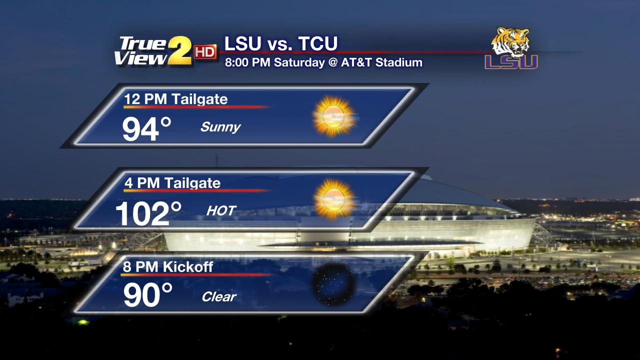
Football Forecast: If you are headed to Dallas for the LSU game this Saturday get ready for a VERY HOT tailgate. It will be mostly sunny with highs in the lower 100s! Fortunately, the game is indoors in Jerry's World, so it will be cool and comfy in there.

If you are headed to Houston for the Southern Game, it will be hot and more humid with highs in the mid 90s during the game.
Next Week Outlook: On Labor Day, Monday, we will have more hot and humid weather as the ridge of high pressure stays to our west. Expect partly cloudy skies with a few showers and storms popping up. Highs will be in the lower 90s and lows in the lower 70s.
A cold front will be sinking into the Southeast U.S on Tuesday and Wednesday. It will pass through Baton Rouge on Wednesday. Each day will have partly to mostly cloudy skies with isolated showers and storms. Highs will be in the lower 90s and lows in the lower to mid 70s.

The front will likely start to drift back to the north on Thursday and Friday. It will dissipate as it moves north, but it will help to set off isolated showers and storms. Highs will stay in the lower 90s and lows in the lower 70s.
Tropical Outlook: I'm still tracking the tropical wave located about 850 miles or so east of the Lesser Antilles. It is poorly organized and is not expected to develop into anything thanks to some strong upper-level wind shear. NHC is only giving it a low chance for development over the next 5 days.

There is a much stronger tropical wave (Invest 96L) emerging off the African Coast into the Atlantic. Conditions are favorable for development over the next 2 days, and a tropical depression could form over the weekend near the Cape Verde Islands. Then the system is forecast to continue to develop as conditions remain favorable once it passes the Cape Verde Islands during the next 5 days, and the NHC is giving it a high chance of becoming a tropical cyclone.
Elsewhere...the tropics are still quiet and they will stay that way through Sunday.
Enjoy the decent weather and have a great Labor Day Weekend! -Dave

The ridge of high pressure will continue to sit over us today. That means more of the same weather with partly cloudy skies, but it will be a tad hotter with high temperatures in the lower 90s.
There will be mostly clear skies tonight, and it will not be as cool. Low temperatures will be in the lower 70s.
Weekend Forecast: The ridge will start to move to the west of Louisiana over the weekend, and a disturbance/upper-level low will move from north to south along the LA/TX border. This will allow us to become hotter and more humid. We could see a spotty shower popping up as well. Therefore, Saturday and Sunday will be partly cloudy with a slight chance of a shower. Highs will be in the lower to mid 90s and lows in the mid 70s each day and night.
Football Forecast: If you are headed to Dallas for the LSU game this Saturday get ready for a VERY HOT tailgate. It will be mostly sunny with highs in the lower 100s! Fortunately, the game is indoors in Jerry's World, so it will be cool and comfy in there.
If you are headed to Houston for the Southern Game, it will be hot and more humid with highs in the mid 90s during the game.
Next Week Outlook: On Labor Day, Monday, we will have more hot and humid weather as the ridge of high pressure stays to our west. Expect partly cloudy skies with a few showers and storms popping up. Highs will be in the lower 90s and lows in the lower 70s.
A cold front will be sinking into the Southeast U.S on Tuesday and Wednesday. It will pass through Baton Rouge on Wednesday. Each day will have partly to mostly cloudy skies with isolated showers and storms. Highs will be in the lower 90s and lows in the lower to mid 70s.
The front will likely start to drift back to the north on Thursday and Friday. It will dissipate as it moves north, but it will help to set off isolated showers and storms. Highs will stay in the lower 90s and lows in the lower 70s.
Tropical Outlook: I'm still tracking the tropical wave located about 850 miles or so east of the Lesser Antilles. It is poorly organized and is not expected to develop into anything thanks to some strong upper-level wind shear. NHC is only giving it a low chance for development over the next 5 days.
There is a much stronger tropical wave (Invest 96L) emerging off the African Coast into the Atlantic. Conditions are favorable for development over the next 2 days, and a tropical depression could form over the weekend near the Cape Verde Islands. Then the system is forecast to continue to develop as conditions remain favorable once it passes the Cape Verde Islands during the next 5 days, and the NHC is giving it a high chance of becoming a tropical cyclone.
Elsewhere...the tropics are still quiet and they will stay that way through Sunday.
Enjoy the decent weather and have a great Labor Day Weekend! -Dave
Comments