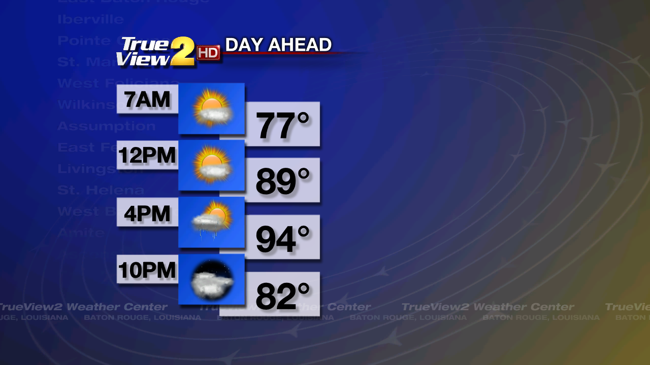
Short Term Forecast: We have a very warm and humid morning across Southeast Louisiana with party cloudy skies and temperatures in the mid to upper 70s. Some showers and storms have also developed along the coast.

You can expect another very hot afternoon in Baton Rouge as the eastern edge of the upper-level ridge of high pressure is still influencing our weather. Along this eastern edge will be a disturbance that will move from the Mid-West toward the Deep South. This disturbance's outflow could help to set off a few showers and storms this afternoon. However, most of you will remain dry. High temperatures will be in the mid 90s with the heat index of 100 to 105.
That disturbance will impact our weather tonight as it helps to send a cold front into Baton Rouge. We will become mostly cloudy with isolated showers and storms developing late tonight. Lows will be in the mid 70s.
Weekend Forecast: A trough of low pressure will be sitting over the Eastern U.S. all weekend and it will help to send the cold front toward us. Saturday will start out with some isolated to scattered showers and storms as the cold front moves into the city. These showers and storms will continue into the afternoon until the cold front moves to the Louisiana Coast. Some of the storms could be strong to possibly severe with gusty winds. Otherwise, we will be partly to mostly cloudy and still hot with highs in the mid 90s. The cold front will be at the coast by Saturday Night and some drier air will build in behind it. This will put an end to the rain and make it mostly clear. It will turn a tad cooler with lows near 70.
The drier air will sit over us on Sunday with partly cloudy skies. A shower or two could pop-up, but mainly closer to the coast where the front will be dissipating. Highs will be in the lower 90s. Sunday Night will still be a little cooler with lows in the upper 60s.

Next Week Outlook: The drier air will persist over Baton Rouge on Monday and Tuesday. We will also not be as hot thanks to that trough of low pressure. Each day will be partly cloudy with only spotty showers possible. Highs will be around 90. It will be a little refreshing at night with clear skies and lows in the upper 60s.
We will see more moisture return on Wednesday through Friday as the trough weakens. This will help to bring back the daily scattered showers and thunderstorms. Highs will be in the upper 80s to lower 90s each day with lows in the lower 70s at night.
Tropical Outlook: The tropics are still quiet and they will stay that way through the weekend.
Plan for some rain tonight/Saturday and have a great weekend! -Dave
You can expect another very hot afternoon in Baton Rouge as the eastern edge of the upper-level ridge of high pressure is still influencing our weather. Along this eastern edge will be a disturbance that will move from the Mid-West toward the Deep South. This disturbance's outflow could help to set off a few showers and storms this afternoon. However, most of you will remain dry. High temperatures will be in the mid 90s with the heat index of 100 to 105.
That disturbance will impact our weather tonight as it helps to send a cold front into Baton Rouge. We will become mostly cloudy with isolated showers and storms developing late tonight. Lows will be in the mid 70s.
Weekend Forecast: A trough of low pressure will be sitting over the Eastern U.S. all weekend and it will help to send the cold front toward us. Saturday will start out with some isolated to scattered showers and storms as the cold front moves into the city. These showers and storms will continue into the afternoon until the cold front moves to the Louisiana Coast. Some of the storms could be strong to possibly severe with gusty winds. Otherwise, we will be partly to mostly cloudy and still hot with highs in the mid 90s. The cold front will be at the coast by Saturday Night and some drier air will build in behind it. This will put an end to the rain and make it mostly clear. It will turn a tad cooler with lows near 70.
The drier air will sit over us on Sunday with partly cloudy skies. A shower or two could pop-up, but mainly closer to the coast where the front will be dissipating. Highs will be in the lower 90s. Sunday Night will still be a little cooler with lows in the upper 60s.
Next Week Outlook: The drier air will persist over Baton Rouge on Monday and Tuesday. We will also not be as hot thanks to that trough of low pressure. Each day will be partly cloudy with only spotty showers possible. Highs will be around 90. It will be a little refreshing at night with clear skies and lows in the upper 60s.
We will see more moisture return on Wednesday through Friday as the trough weakens. This will help to bring back the daily scattered showers and thunderstorms. Highs will be in the upper 80s to lower 90s each day with lows in the lower 70s at night.
Tropical Outlook: The tropics are still quiet and they will stay that way through the weekend.
Plan for some rain tonight/Saturday and have a great weekend! -Dave
Comments