
Severe Weather Possible Late Tonight & On Monday

The old cold front that brought us the rain and storms last week will come back north as a warm front tonight/Monday Morning.  As this happens, another cold front will move in from the west.  We will become very unstable as the warm and humid air is ushered in from the Gulf, and it will become breezy too.  All of this will allow scattered to numerous showers and thunderstorms to pop-up.  The rain & storms will start this evening, but will become much more widespread on Monday.  There may be some breaks in the rain & storms, but it is not expected to come to an end until Monday Night.

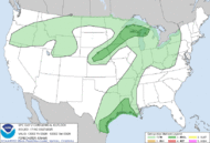
Any of the storms that develop could become strong to severe!  This severe weather event looks to be stronger than the last few and we could have a possible outbreak!!  That means we could have more widespread severe weather verses just a small threat.  The reason is that we will be much more unstable and more severe weather variables will be in place this time.  The SPC has us in a Slight Risk for severe weather due to the mentioned factors.  We could have large hail (1"+ in size), damaging winds (60 mph or greater), and even a few tornadoes on Monday.  The threat will remain until the cold front passes through Baton Rouge and that should happen by Monday Evening as of right now.  It is likely that a squall line of thunderstorms will move through with the cold front by Monday Evening, and this will also give us the chance of seeing some severe weather with damaging winds.

On top of the severe weather threat, we will also have heavy rain falling.  The forecast models are indicating we could pick up 1 to 3 inches or rain with a few spots getting closer to 6 inches.  This could cause Flash Flooding and the NWS in Slidell, LA has issued a Flash Flood Watch for Livingston, Tangipahoa, St. Helena Parishes and Amite & Pike Counties in Mississippi from 9 PM tonight until Monday Evening.  Those Parishes/Counties are expected to get some of the heaviest rains.  Depending on how much rain fall, more Parishes/Counties could be added according to the NWS.

Please stay tuned to WBRZ, WBRZ Weather Channel and my Facebook & Twitter feeds for additional updates - especially on Monday.  I will have full coverage on 2une In Monday Morning.

Stay safe and aware! -Dave
Comments

Pam Leger said…
Thanks for the update. Hope it will get better as the week moves on. We can't have any rain Friday, Saturday or Sunday for the LSU games.

Popular posts from this blog

Flash Flood Watch now until Thursday Evening for WBRZ Viewing Area

The NWS in Slidell, LA has issued a  Flash Flood Watch for all of the WBRZ Viewing Area starting now and continuing until Thursday Evening. Rain has been falling for the last few hours and we have already picked up over 1.30" in Baton Rouge.  This is WAY more than the forecast models were predicting for this time.  The area of low pressure continues to develop over South Texas and a warm front will move up from the Gulf of Mexico by Wednesday Morning.  This will spread widespread rain and a few thunderstorms over Southern Louisiana all night and into Wednesday.  Then it looks like we will taper off the rain to just scattered showers during the day on Wednesday. On Wednesday Night, a cold front will move out of Texas into Louisiana.  As this happens, a squall line of thunderstorms is expected to move ahead of it and through Baton Rouge on Thursday Morning.  Some of these storms could be strong to severe with damaging winds and a few tornadoes. ...

The Great Flood of 1983

It was 30 years ago that the Baton Rouge area experienced what is likely the worst flood in its history!  On April 5-9, 1983 we were hit with 6 to 13 inches of rain from a slow-moving storm.  This rain quickly ran off into the Amite, Comite, Tickfaw and Tangipahoa River Basins.  Some of the highest rainfall totals were in the headwaters of the Amite River in the Felicianas and South Mississippi.  Also, there were some strong easterly winds which slowed down the water from draining into Lake Maurepas and Pontchartrain.  These were some of the reasons why the flooding occurred in Baton Rouge & Denham Springs.  The weather map to the right shows the weather for April 8, 1983. A stalled front over the Southeast U.S. lead to the heavy rain event and flooding. The rivers quickly rose and spilled out of their banks.  The rain didn't stop, so the water continued to rise and rise.  Rivers rose to what are still the record levels.  The Amite in D...

The Unseasonably Cool Weather Continues

Short Term Forecast :  It is a very cold morning across the Capital City with clear skies and temperatures in the 30s.  A light freeze is expected!  I hope that you brought in your plants last night.  Take that jacket with you this morning. An area of high pressure remains over the Southeast U.S. today.  This will keep us sunny and with the northwest winds over us, we will stay cool.  High temperatures will be in the upper 50s. Another freeze is expected tonight for the Baton Rouge area.  We will be clear with calm winds and very good radiational cooling.  Low temperatures will fall into the upper 20s to lower 30s.  The NWS has issued a Freeze Warning for areas along and north of the I-10/12 corridor from 2 AM to 8 AM Wednesday Morning.  The freeze could last 2 to 6+ hours and that would be long enough to kill any vegetation.  Make sure you bring in your plants or at least cover them tonight!  Bundle ...