 An area of high pressure will sit just east of Louisiana today and Friday. This will allow southerly winds to return and they will warm us back up. We will be mostly sunny with highs in the lower 80s today. Tonight will be mostly clear with some patchy fog. Lows will be in the 50s north and 60s south of the lake.
  The Saints are headed to Charlotte to take on the Panthers tonight for Thursday Night Football. It will be cool, but could be pretty smoky as the wildfires continue just west of Charlotte. If it is not too smoky, it will smell like a campfire for the entire game. Kickoff temperatures will be in the 60s and it will fall into the 50s by the end of the game.
 A strong cold front will move through Southeast Louisiana on Friday Night into Saturday Morning. There will be enough moisture over us for the front to set off spotty showers and maybe a thunderstorm. Lows will be in the mid 50s.
Any rain will come to an end on Saturday Morning and then we will become clear, windy and MUCH COOLER with highs only in the lower 60s. Saturday Night will be clear and breezy with MUCH COLDER lows in the upper 30s north and upper 40s south.
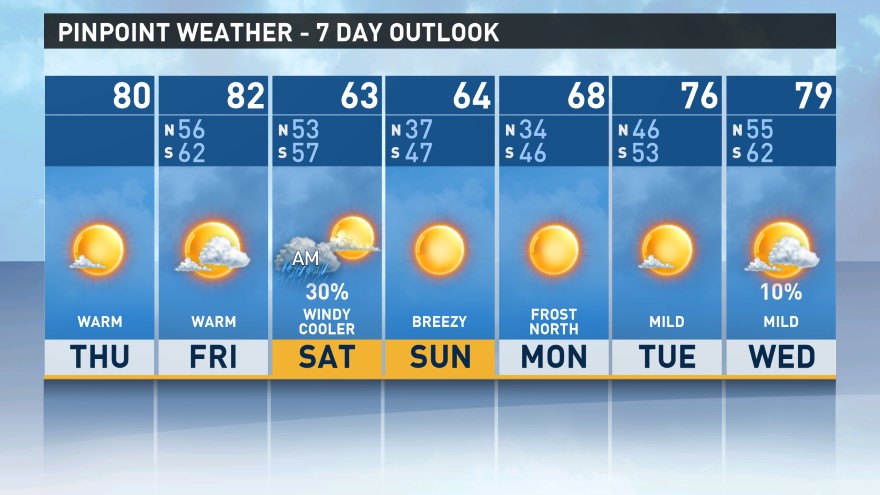 An area of high pressure builds back over us on Sunday with plenty of sunshine for us. It will stay cool with highs only in the lower 60s. Sunday Night will be even colder with patchy frost possible north of the lake. Be prepared to cover the plants and protect pets! Lows will be in the mid 30s north and mid 40s south. Bundle up as you head back to work on Monday! -Dave
Comments