Some of you have been calling to say that Matthew's forecast to do a loop in the Atlantic Ocean off the SE U.S. is the same as what Hurricane Betsy did back in 1965. Well...that is not true.
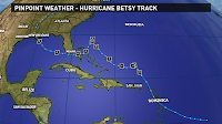 Betsy formed on August 27, 1965 just off the Leeward Islands. It quickly became a tropical storm on the same day, and then became a hurricane on August 29. It made a few loops in its track with one north of Puerto Rico and a second north of the Bahamas. There is a strong area of high pressure that was preventing Betsy from moving to the north, and that is what caused it to loop. After the second loop, it then moved SW across the Bahamas, then turned west to move over far South Florida and then into the Gulf. It eventually turned to the NW and quickly tracked right to New Orleans where it made landfall as a major hurricane on September 9th.
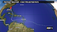 Hurricane Matthew formed in the Atlantic east of the Leeward Islands as a tropical storm on September 28. It quickly moved west into the Caribbean where it rapidly intensified into a Cat. 5 hurricane. The storm turned NW and then North to make a 1st landfall over the Western Tip of Haiti, then is crossed the Bahamas as a Cat. 4 hurricane and currently is just off the Florida East Coast as a Cat. 3. Matthew is forecast to stay off the Carolina Coast and turn SE and then SW and loop back around toward the Bahamas thanks to a strong area of high pressure over the NE U.S. and North Atlantic Ocean.
Are these two hurricane similar with their track/forecast track? The answer is yes and no. Yes, because they are both being blocked by a large area of high pressure over the North Atlantic, and this is preventing them from moving to the north.
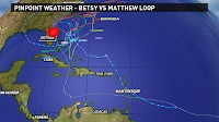 No, for a few reasons. One, they are in different times of year. Betsy was in September during the peak of hurricane season, and Matthew is occurring in October near the secondary peak of hurricane season. This makes a big difference since the water temps. are cooler in October, and we have more cold fronts and troughs moving across the Southern U.S. this time of year. Whereas in September, you don't have the cold fronts moving as far south.
Two, Betsy's loop was much smaller and it was a much stronger hurricane when it looped and moved over the Bahamas. Matthew forecast to be a weak tropical storm when it could move over the Bahamas. Plus, Matthew's loop is MUCH larger, and it could loop over the same water it originally moved over as a Cat. 4. That means the water has been churned up and the up-welling would have cooled down the water temperatures.
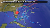 Lastly, Betsy was able to move NW across the Gulf since it rode along the backside of the high pressure area, or path with the least resistance. Matthew is forecast to stay to the south as a trough of low pressure and cold front will keep it from moving into the Northern Gulf - preventing it from coming to Louisiana. Actually, Matthew may be nothing more than a weak low or tropical depression by the time it gets to Bahamas, Florida Straits or Cuba.
Therefore, while the two systems may have done a loop, it is two WAY difference situations, conditions, strengths and time of year. You can't really compare them and say they are similar because they really are not.
I hope that helps with you thinking that Matthew will follow the same path and strength Betsy did. As always, I will continue to track Matthew and bring you the latest updates here and on my Twitter/Facebook pages. -Dave
 Betsy formed on August 27, 1965 just off the Leeward Islands. It quickly became a tropical storm on the same day, and then became a hurricane on August 29. It made a few loops in its track with one north of Puerto Rico and a second north of the Bahamas. There is a strong area of high pressure that was preventing Betsy from moving to the north, and that is what caused it to loop. After the second loop, it then moved SW across the Bahamas, then turned west to move over far South Florida and then into the Gulf. It eventually turned to the NW and quickly tracked right to New Orleans where it made landfall as a major hurricane on September 9th.
 Hurricane Matthew formed in the Atlantic east of the Leeward Islands as a tropical storm on September 28. It quickly moved west into the Caribbean where it rapidly intensified into a Cat. 5 hurricane. The storm turned NW and then North to make a 1st landfall over the Western Tip of Haiti, then is crossed the Bahamas as a Cat. 4 hurricane and currently is just off the Florida East Coast as a Cat. 3. Matthew is forecast to stay off the Carolina Coast and turn SE and then SW and loop back around toward the Bahamas thanks to a strong area of high pressure over the NE U.S. and North Atlantic Ocean.
Are these two hurricane similar with their track/forecast track? The answer is yes and no. Yes, because they are both being blocked by a large area of high pressure over the North Atlantic, and this is preventing them from moving to the north.
 No, for a few reasons. One, they are in different times of year. Betsy was in September during the peak of hurricane season, and Matthew is occurring in October near the secondary peak of hurricane season. This makes a big difference since the water temps. are cooler in October, and we have more cold fronts and troughs moving across the Southern U.S. this time of year. Whereas in September, you don't have the cold fronts moving as far south.
Two, Betsy's loop was much smaller and it was a much stronger hurricane when it looped and moved over the Bahamas. Matthew forecast to be a weak tropical storm when it could move over the Bahamas. Plus, Matthew's loop is MUCH larger, and it could loop over the same water it originally moved over as a Cat. 4. That means the water has been churned up and the up-welling would have cooled down the water temperatures.
 Lastly, Betsy was able to move NW across the Gulf since it rode along the backside of the high pressure area, or path with the least resistance. Matthew is forecast to stay to the south as a trough of low pressure and cold front will keep it from moving into the Northern Gulf - preventing it from coming to Louisiana. Actually, Matthew may be nothing more than a weak low or tropical depression by the time it gets to Bahamas, Florida Straits or Cuba.
Therefore, while the two systems may have done a loop, it is two WAY difference situations, conditions, strengths and time of year. You can't really compare them and say they are similar because they really are not.
I hope that helps with you thinking that Matthew will follow the same path and strength Betsy did. As always, I will continue to track Matthew and bring you the latest updates here and on my Twitter/Facebook pages. -Dave
Comments
jordan shoes
supreme clothing
kobe shoes
canada goose jacket
jordan 4
steph curry shoes
jordan shoes
calvin klein outlet
stephen curry shoes