Remembering Hurricane Ivan - 12 years ago today


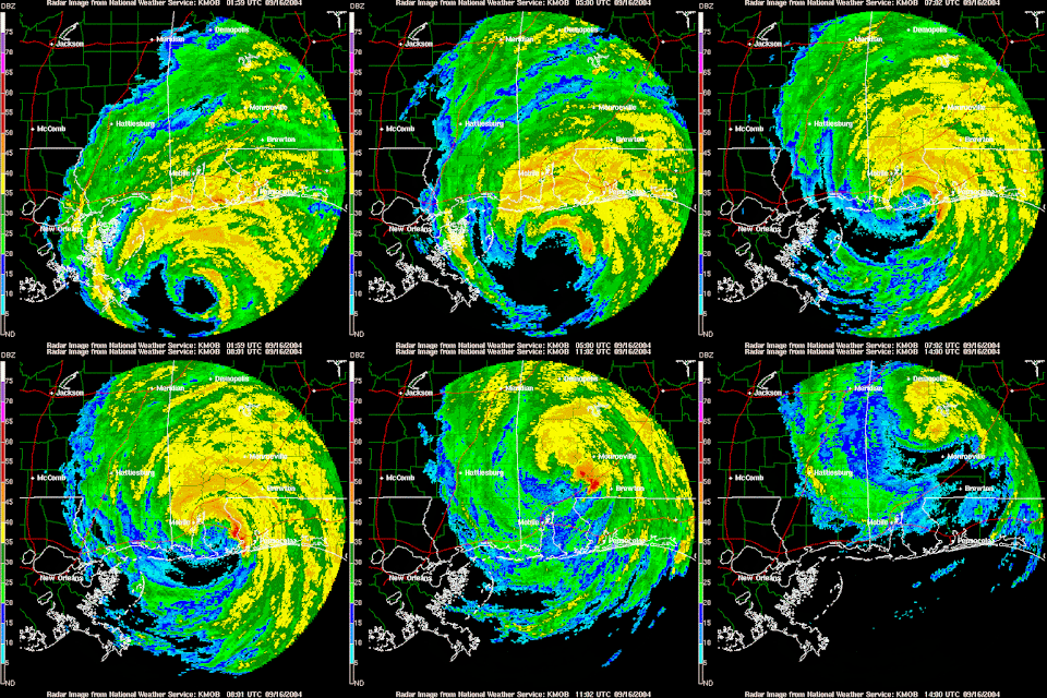
Hurricane Ivan made landfall 12 years ago today at 1:50 AM just west of Gulf Shores, AL as a Category 3 Hurricane.  Winds were sustained at 120 mph at landfall.  There was significant damage, and some say it was worse than Opal (1995) and Frederic (1979).  Damage was estimated to be near $14 Billion. There were 8 deaths in the Western Florida Panhandle directly related to Ivan. 


Ivan was the first hurricane I covered when I moved to Baton Rouge. I was sent to Mobile to cover the storm Live for WBRZ.  My crew and I worked continuously for over 24 hours straight to bring Baton Rougians the latest information about the storm and the places they go to vacation each year.  I remember when the western eye wall moved over us.  Winds were sustained around 100 mph with higher gusts.  I could lean backwards in the wind and not fall down! It was just incredible.  

Once the storm moved to the north, we ventured out to cover the devastation.  Power was out everywhere.  As we drove down Highway 59 on the Eastern Shore of Mobile Bay, damage was becoming more extensive as we got into Foley and eventually Gulf Shores.  You could see the debris from the storm surge up from the coast for miles.  Condos along the beach were missing their Gulf facing walls. Homes and restaurants were missing with only slabs showing. Needless to say, this was the worst devastation I had ever seen...at that time (Of course it was much worse with Katrina in 2005). 

This storm proved that Louisiana was NOT ready for a major hurricane - especially with an evacuation plan! It took people well over 12 hours to get to Baton Rouge!  I call this hurricane a blessing in disguise since it made the local and state officials come up with a better evacuation plan ASAP!  No one would have thought that we would need that plan in less than a year for Hurricane Katrina! 

Here is a look at Ivan making landfall from the Mobile, AL NWS Doppler Radar:


The maximum storm surge along the coastlines of MS, AL and FL ranged from 10-15 feet according to the NWS Mobile. Fortunately, for downtown Mobile, the center of Ivan passed to the east of the city.  Had Ivan made landfall west of Mobile Bay, it is possible that nearly 16 to 18 feet of devastating surge would have impacted downtown! 

As you can see, we are still vulnerable for hurricanes throughout the month of September.  Don't let your guard down, and stay prepared this ENTIRE hurricane season. -Dave


Comments

Popular posts from this blog

The Unseasonably Cool Weather Continues

Short Term Forecast :  It is a very cold morning across the Capital City with clear skies and temperatures in the 30s.  A light freeze is expected!  I hope that you brought in your plants last night.  Take that jacket with you this morning. An area of high pressure remains over the Southeast U.S. today.  This will keep us sunny and with the northwest winds over us, we will stay cool.  High temperatures will be in the upper 50s. Another freeze is expected tonight for the Baton Rouge area.  We will be clear with calm winds and very good radiational cooling.  Low temperatures will fall into the upper 20s to lower 30s.  The NWS has issued a Freeze Warning for areas along and north of the I-10/12 corridor from 2 AM to 8 AM Wednesday Morning.  The freeze could last 2 to 6+ hours and that would be long enough to kill any vegetation.  Make sure you bring in your plants or at least cover them tonight!  Bundle ...

Major Snowstorm Headed To Northeast US Tomorrow

For all of my friends and family that live in the Northeast US...here is my latest analysis of the winter storm heading your way on Friday into Saturday: The same area of low pressure that brought the heavy rain and thunderstorms to Louisiana last night and this morning will be moving up the East Coast on Friday.  It will get much stronger and become a  Nor' Easter that will impact all the major cities from Philly to NYC to Boston as well as inland areas. Delmarva to NJ Coastal Areas :  Winter Storm Warning in effect from Friday AM until Saturday AM!  It looks like it will start out as a brief period of snow along the coast in the morning then change into a windy rain during the day.  Then go to a heavy snow late Friday into Saturday Morning.  Snow accumulations of 4-8" are possible.  Some minor ice accumulations are possible too. Winds will be sustained around 30+ mph and coastal erosion will be possible too. NE PA : Winter Storm Warning from 10...

Flash Flood Watch now until Thursday Evening for WBRZ Viewing Area

The NWS in Slidell, LA has issued a  Flash Flood Watch for all of the WBRZ Viewing Area starting now and continuing until Thursday Evening. Rain has been falling for the last few hours and we have already picked up over 1.30" in Baton Rouge.  This is WAY more than the forecast models were predicting for this time.  The area of low pressure continues to develop over South Texas and a warm front will move up from the Gulf of Mexico by Wednesday Morning.  This will spread widespread rain and a few thunderstorms over Southern Louisiana all night and into Wednesday.  Then it looks like we will taper off the rain to just scattered showers during the day on Wednesday. On Wednesday Night, a cold front will move out of Texas into Louisiana.  As this happens, a squall line of thunderstorms is expected to move ahead of it and through Baton Rouge on Thursday Morning.  Some of these storms could be strong to severe with damaging winds and a few tornadoes. ...