Short Term Forecast: We have a partly cloudy morning with some patchy fog across Southeast Louisiana. It is mild with temperatures in the lower 60s.
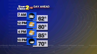
Get ready for some Spring-like weather this afternoon thanks to an area of high pressure sitting over the Southeast U.S. This is giving us southeast winds which are pumping in the warm and humid air from the Gulf of Mexico. We will be partly cloudy with high temperatures in the mid 80s today.
Some clouds will stick around tonight along with areas of patchy fog. It will be mild and a little muggy with low temperatures in the mid 60s.
Week Ahead: More of the same Spring-like weather is on tap for Wednesday. We will stay partly cloudy with highs in the mid 80s. Wednesday Night will have partly to mostly cloudy skies with warm low temperatures in the upper 60s.

The weather will drastically change on Thursday, Halloween. A strong trough of low pressure will be moving east across the U.S. This will send a cold front into Louisiana during the afternoon and evening hours. Scattered showers and thunderstorms will form ahead and along the front. It is likely that a squall line will be racing east across the state during the evening and overnight hours. Some of these storms could be strong to possibly severe with damaging winds and a tornado or two is possible thanks to the strong wind shear aloft. It will be warm and humid ahead of the front with highs in the lower 80s.
Thursday Night will have plenty of rain and thunderstorms as the squall line moves through. Lows will be in the upper 60s. I will continue to monitor this and hope that the line of storms moves through after the trick-or-treating time.
The cold front will move east of Baton Rouge on Friday Morning, and stall along the coast. Then a disturbance will push through Louisiana and this will move the front to the east of us. This will finally cool the temperatures down. We will become partly cloudy by the afternoon hours. High temperatures will be in the upper 70s. Friday Night will be mostly clear and much cooler with lows near 50.
Weekend Forecast: An area of high pressure will build over the Southeast U.S. all weekend. We will have some gorgeous weather on Saturday and Sunday, but it will be MUCH COOLER. It will be sunny and much cooler with highs in the lower 70s. Each night will be clear and CHILLY with lows in the mid 40s.
Tropical Outlook: All areas of the tropics are staying quiet and they are forecast to remain quiet through Wednesday.
Enjoy the warm-up and have a nice Tuesday! -Dave
Comments