Short Term Forecast: It is a much quieter morning compared to Wednesday! We have partly cloudy skies with some patchy fog. Temperatures are in the lower to mid 70s.

We will not have as many storms as we did yesterday thanks to the upper-level disturbance (low pressure in the upper-levels of the atmosphere) moving to the east of Louisiana. An area of high pressure is going to build over Louisiana and that will bring in some drier air aloft. This will limit the amount of storms we will have during the heating of the day. Therefore, expect partly cloudy skies with isolated showers and thunderstorms. Highs will be in the lower 90s.
Any rain/storms will dissipate by 10 PM and then we will be left with a few clouds. It will be warm and muggy with lows in the lower 70s.
Friday will be another hotter day with only a few pop-up afternoon storms as the drier air loft remains over Baton Rouge. Highs will be in the lower 90s. Friday Night will be partly cloudy and steamy with lows in the lower 70s.
Weekend Outlook: The area of high pressure will move east of Louisiana, and another disturbance will move over the state. This will increase the chance of rain all weekend, but we will not have a washout. Saturday will be partly cloudy with isolated showers and storms. Highs will be in the lower 90s and lows in the lower 70s.

We will have a little better chance of storms on Sunday. Expect a mix of sun and clouds with scattered storms in the afternoon hours. Highs will be in the lower 90s and lows in the lower 70s Sunday Night.
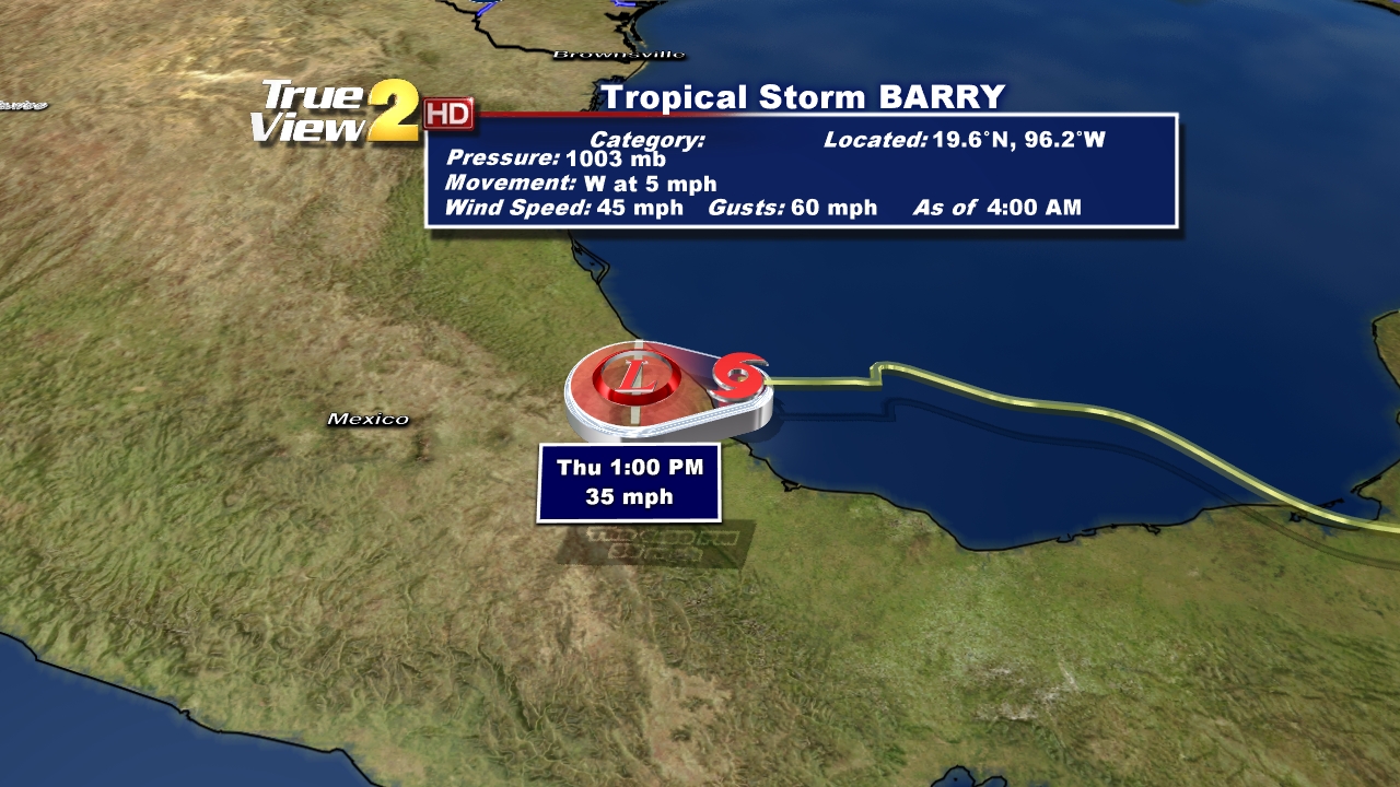
Tropical Outlook: TD #2 became Tropical Storm Barry yesterday afternoon. It is making landfall near Veracruz, Mexico with winds of 45 mph. It will continue to move inland and weaken today and tomorrow.

Elsewhere...the rest of the tropics are still quiet.
Watch out for some rain today and have a great one! -Dave

We will not have as many storms as we did yesterday thanks to the upper-level disturbance (low pressure in the upper-levels of the atmosphere) moving to the east of Louisiana. An area of high pressure is going to build over Louisiana and that will bring in some drier air aloft. This will limit the amount of storms we will have during the heating of the day. Therefore, expect partly cloudy skies with isolated showers and thunderstorms. Highs will be in the lower 90s.
Any rain/storms will dissipate by 10 PM and then we will be left with a few clouds. It will be warm and muggy with lows in the lower 70s.
Friday will be another hotter day with only a few pop-up afternoon storms as the drier air loft remains over Baton Rouge. Highs will be in the lower 90s. Friday Night will be partly cloudy and steamy with lows in the lower 70s.
Weekend Outlook: The area of high pressure will move east of Louisiana, and another disturbance will move over the state. This will increase the chance of rain all weekend, but we will not have a washout. Saturday will be partly cloudy with isolated showers and storms. Highs will be in the lower 90s and lows in the lower 70s.

We will have a little better chance of storms on Sunday. Expect a mix of sun and clouds with scattered storms in the afternoon hours. Highs will be in the lower 90s and lows in the lower 70s Sunday Night.
Tropical Outlook: TD #2 became Tropical Storm Barry yesterday afternoon. It is making landfall near Veracruz, Mexico with winds of 45 mph. It will continue to move inland and weaken today and tomorrow.
Elsewhere...the rest of the tropics are still quiet.
Watch out for some rain today and have a great one! -Dave
Comments