Short Term Forecast: It is a mild start to the day with mostly clear to partly cloudy skies across the Baton Rouge area. Some patchy fog is possible. Temperatures are in the upper 50s.
 We will have another pleasant afternoon thanks to high pressure sitting east of Louisiana. This is allowing south to southeast winds to usher in the warm and more humid air from the Gulf of Mexico. We will have partly to mostly cloudy skies with high temperatures in the lower 80s.
We will keep the clouds tonight and some fog will be possible again. It will be a pretty warm night with low temperatures only in the mid 60s.
Week Ahead: More of the same weather is on tap for Tuesday with partly cloudy skies. Highs will be in the lower 80s and lows in the upper 60s on Tuesday Night with some fog and clouds.
The weather will start to change on Wednesday as a cold front moves toward Louisiana. Most of the day will be dry with partly to mostly cloudy skies. However, later in the day we will see isolated showers and thunderstorms popping up ahead of the cold front. Some of the storms could be strong to severe at times. We will be warm and humid with highs in the lower 80s.
 The cold front will move into Baton Rouge on Wednesday Night/Thursday Morning according to the GFS model. This model seems to be the most consistent at this time. It is likely that a squall-line of thunderstorms will move into Baton Rouge by daybreak Thursday. These storms are expected to be strong to severe with damaging winds, large hail and possibly a few tornadoes. SPC has much of Louisiana in a Slight Risk. Lows will be in the lower 60s.
Showers and storms will continue through the morning on Thursday before clearing out by the afternoon hours. However, if the front slows down then we will see the rain and storms all day Thursday. They are still expected to be strong to severe! High temperatures will be in the lower 70s. Thursday Night will become mostly clear and much colder. Lows will fall to the upper 40s.
 An area of high pressure will build over the Southeast U.S. on Friday. We will be sunny and still warm with high temperatures in the mid 70s and low temperatures near 50 on Friday Night.
Weekend Outlook: The area of high pressure will remain over the Southeast U.S. all weekend. This means we will have plenty of sunshine each day and it will stay warm. Highs will be in the mid to upper 70s and lows in the lower to mid 50s each day and night.
Enjoy the Spring warmth today! Have a great one! -Dave
 We will have another pleasant afternoon thanks to high pressure sitting east of Louisiana. This is allowing south to southeast winds to usher in the warm and more humid air from the Gulf of Mexico. We will have partly to mostly cloudy skies with high temperatures in the lower 80s.
We will keep the clouds tonight and some fog will be possible again. It will be a pretty warm night with low temperatures only in the mid 60s.
Week Ahead: More of the same weather is on tap for Tuesday with partly cloudy skies. Highs will be in the lower 80s and lows in the upper 60s on Tuesday Night with some fog and clouds.
The weather will start to change on Wednesday as a cold front moves toward Louisiana. Most of the day will be dry with partly to mostly cloudy skies. However, later in the day we will see isolated showers and thunderstorms popping up ahead of the cold front. Some of the storms could be strong to severe at times. We will be warm and humid with highs in the lower 80s.
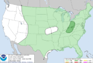 The cold front will move into Baton Rouge on Wednesday Night/Thursday Morning according to the GFS model. This model seems to be the most consistent at this time. It is likely that a squall-line of thunderstorms will move into Baton Rouge by daybreak Thursday. These storms are expected to be strong to severe with damaging winds, large hail and possibly a few tornadoes. SPC has much of Louisiana in a Slight Risk. Lows will be in the lower 60s.
Showers and storms will continue through the morning on Thursday before clearing out by the afternoon hours. However, if the front slows down then we will see the rain and storms all day Thursday. They are still expected to be strong to severe! High temperatures will be in the lower 70s. Thursday Night will become mostly clear and much colder. Lows will fall to the upper 40s.
 An area of high pressure will build over the Southeast U.S. on Friday. We will be sunny and still warm with high temperatures in the mid 70s and low temperatures near 50 on Friday Night.
 Weekend Outlook: The area of high pressure will remain over the Southeast U.S. all weekend. This means we will have plenty of sunshine each day and it will stay warm. Highs will be in the mid to upper 70s and lows in the lower to mid 50s each day and night.
Enjoy the Spring warmth today! Have a great one! -Dave
Comments
capital to claim that I acquire actually enjoyed account your blog posts.
Any way I will be subscribing on your augment and even I fulfillment you get entry
to consistently fast.
my page; healthy diet plans for women
Also visit my web blog: how to lose weight quickly